Nature Tech for Green AI Careers
- Edu-Nomad

- Jan 11
- 2 min read
Every day, over 100 million gigabytes of environmental data stream from satellites and sensors orbiting the Earth. Translating this data into usable action requires artificial intelligence — and that’s where nature tech emerges as a game-changer.
AI and remote sensing now underpin many nature-based solutions, from reforestation to flood-risk mapping. When combined, these tools offer a precise, scalable way to understand land cover, vegetation health and water systems without relying solely on fieldwork.
“Nature tech is not just about better data — it’s about faster, fairer decisions for people and the planet.”
In Australia, this integration is visible across multiple sectors:
CSIRO’s “Everyday AI” helps protect the Great Barrier Reef, using onboard machine-learning models to detect crown-of-thorns starfish. In one trial, AI identified 20 starfish where a human expert found just one — multiplying conservation efficiency.
CSIRO’s biodiversity AI tools guide investment in threatened-species management, even where ecological data are scarce.
Northern Territory UAV LiDAR projects track habitat change at scale, supporting regulators and landholders in mitigation planning.
Queensland’s Copernicus Australasia hub provides near-real-time vegetation data for land-condition assessments and compliance.
Together, these examples illustrate a quiet revolution: data is becoming a shared asset for environmental and economic resilience.
From pixels to restored ecosystems: a practical framework
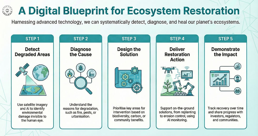
Platforms such as Google Earth Engine, Restor. eco and Copernicus Open Access Hub enable this entire cycle with minimal cost, democratising access to environmental intelligence.
AI for climate-ready communities
AI and remote sensing are also transforming adaptation finance — helping investors and governments measure the value of resilience.
A World Resources Institute (2025) study of 320 projects across 12 countries found that every $1 invested in climate adaptation delivers over $10 in benefits over ten years, with average returns of 27%. Nearly half of these investments also reduced emissions, reinforcing the economic case for “nature-positive” development.
For councils, utilities and infrastructure planners in Australia, this evidence matters. By using digital twins, flood-risk maps and vegetation-index data, they can test scenarios before investing — reducing losses and improving community trust.
Green AI careers and future skills
The rise of nature tech isn’t just an environmental story—it’s a workforce revolution driving Green AI careers and future skills.
Professionals reskilling now will lead this green boom: “Green skills mean 25% faster hires in Australia, with 78 million global jobs incoming by 2030”.
Pitfalls and “good–better–best” practice
Stage | Good | Better | Best |
Data use | Ad-hoc satellite imagery for reporting | Routine monitoring via free tools | Continuous AI-assisted analytics integrated into ESG dashboards |
Skills | Upskilling individual teams | Embedding green-skills training across business units | Organisation-wide “climate capability” frameworks |
Equity | Access to open data | Partnerships with local councils or Indigenous ranger groups | Co-design with communities, ensuring data sovereignty and benefit-sharing |
Avoid “tech for tech’s sake.” The most successful projects treat AI and sensors as part of human-centred systems that value local knowledge as much as digital insight.
Measuring success
Look beyond outputs to outcomes. Useful indicators include:
🔸Reduced fieldwork time and monitoring costs
🔸Measurable habitat recovery (e.g., NDVI vegetation index)
🔸Faster detection of ecological threats
🔸Number of staff trained in data-driven decision-making
🔸Partnerships or co-authored community reports
🔸Progress toward ESG or nature-positive goals
Quick-start checklist

“Nature tech turns data into stewardship — helping people, organisations and ecosystems thrive together.”